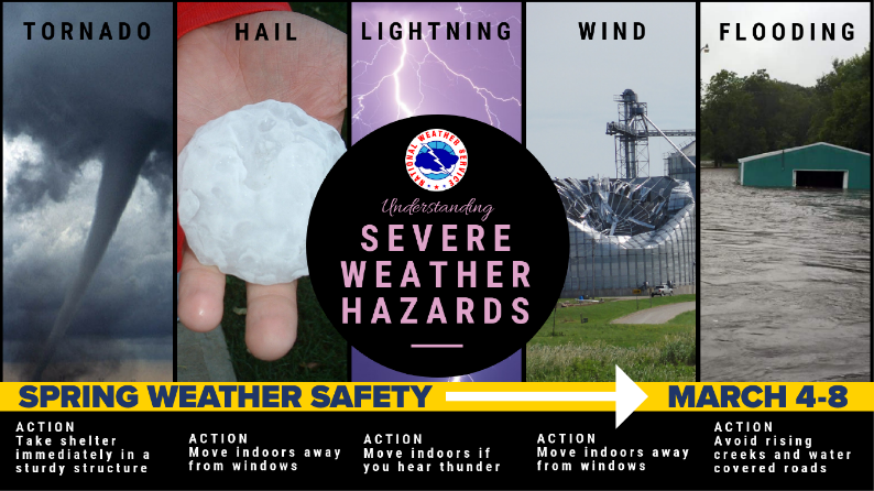
(Harris County, TX) – Springtime in southeast Texas offers plenty of pleasant days, but it also brings the threat of severe weather. The Harris County Office of Homeland Security & Emergency Management (HCOHSEM) and the National Weather Service (NWS) want to remind residents of the unpredictability of the season during its Spring Severe Weather Safety Campaign that runs March 4-8, 2019.
“Spring is a time of renewal and we want to take this opportunity to give a refresher on the seasonal threats from severe weather and how to stay safe,” said Harris County Judge Lina Hidalgo. “Preparation is important year round and we can best do that by staying informed, having an emergency plan and essential supplies.”
Understanding the difference between a warning and a watch:
- A watch indicates that the potential exists for the development of severe weather.
- A warning is more serious and requires more immediate action. It indicates that severe weather conditions are occurring or imminent.
HCOHSEM reminds residents that severe weather can develop rapidly and with little warning, and offers some life-saving tips for the following threats:
Thunderstorms
- Keep an eye out for signs of a coming storm, including darkening skies, increasing winds or flashes of lightning.
- If you can hear thunder, you are close enough to the storm to be in danger from lightning, which kills 40-50 people per year.
- Postpone outdoor activities if a storm is imminent; lightning often strikes where it is not raining.
- Take shelter in a sturdy building or vehicle, with doors and windows securely fastened.
- Stay away from windows and avoid taking a bath, shower or using plumbing until the storm has passed.
Flash Flooding
- Drivers should never underestimate the force and power of flood waters. If you see high water, turn around, don’t drown!
- Waters can rise so rapidly that they may be far deeper by the time you are halfway across, trapping you in your vehicle.
- Six inches of water can cause tires to lose traction and begin to slide, 12 inches of water can float many cars, and two feet of rushing water will carry off pick-up trucks, SUVs, and most other vehicles.
- Flash floods are especially treacherous at night when it is very difficult to see how deep waters may be or how fast water is rising.
- Floodwater weakens roadbeds. Drivers should proceed cautiously after waters have receded, since the road may collapse under the weight of the vehicle.
Tornadoes
- There are several distinct things to look out for that indicate a tornado may be on its way: dark, often greenish clouds, large hail, a funnel or wall cloud, or a roaring noise.
- Monitor local media for storm information, as well as NOAA weather radio.
- Seek shelter in an interior room on the lowest floor of a home or building away from windows: a stairwell, bathroom, hallway or storage closet.
- Do not stay in a mobile home.
- At work and school, follow the drill and go to a designated shelter area, usually interior hallways on the lowest floor. Avoid auditoriums, gyms and areas with wide, free-span roofs.
- If you are in a car, do not try to outrun a tornado and avoid bridges/overpasses. If you see flying debris, pull over and park. Keep your seat belt on and the engine running. Put your head down below the windows, and cover yourself with your hands/arms or a blanket.
- If outdoors, seek shelter in a sturdy building. If no shelter, lie flat and face-down on low ground, protecting the back of your head with your arms. Get as far away from trees and cars as you can.
Remember to always have a plan and stay informed to protect yourself from severe weather threats. Residents are encouraged to monitor the local NWS forecast at www.weather.gov/hgx/. Go to ReadyHarris.org to sign up for emergency alerts.